Just a heads-up that the World Wide Help Group is blogging about the floods in Suriname at http://worldwidehelp.blogspot.com/.
Information from and about Suriname in general, and the flood situation in particular would be most appreciated. As would information about aid efforts, whether official, NGO-led or ad-hoc, national or international. Mail us at suriname[AT]worldwidehelp[DOT]info.
And we could really use your help if you can translate from and to Dutch.
From the Associated Press:
A magnitude-8.0 earthquake struck early Thursday near the South Pacific nation of Tonga, the U.S. Geological Survey said. A tsunami warning was issued for Fiji and New Zealand.
The temblor, classified by the USGS as a "great" quake, struck 95 miles south of Neiafu, Tonga, and 1,340 miles north-northeast of Auckland, New Zealand.
The U.S. Pacific Tsunami Warning Center issued the tsunami warning but said it was not known whether the quake generated a potentially deadly giant wave.
The Following Earthquake has been Reported:
Date: 2006/03/31 21:14:40.8
Region: Talaud Islands, Indonesia
Magnitude: Mo 6.1
Latitude: 3.8947 N
Longitude: 126.3045 E
Institute: NEI
Injured Exp. min/max: 0 / 0
Fatalities Exp. min/max: 0 / 0
The earthquake is located 40 km off shore. Only small settlements along the coast.
More Information can be found here:
http://www.wapmerr.org/user_quake.htm
Date: 2006/03/31 21:14:40.8
Region: Talaud Islands, Indonesia
Magnitude: Mo 6.1
Latitude: 3.8947 N
Longitude: 126.3045 E
Institute: NEI
Injured Exp. min/max: 0 / 0
Fatalities Exp. min/max: 0 / 0
The earthquake is located 40 km off shore. Only small settlements along the coast.
More Information can be found here:
http://www.wapmerr.org/user
Associated Press
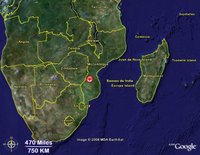
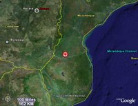
Feb. 22 - An earthquake with an estimated magnitude of 7.5 struck Mozambique, the U.S. Geological Survey said Wednesday. There was no immediate word on injuries or damages.
The quake hit at 12:19 a.m. Thursday local time. Its epicenter was 140 miles southwest of Beira, on Mozambique's Indian Ocean coast, USGS spokeswoman Clarice Ransom said. She said the initial reading had been 6.9 but was adjusted upward.
The earthquake was felt as far away as Durban, South Africa, and Harare, Zimbabwe.
A newspaper editor in Maputo said he was in the 11th floor of an apartment building that was rocked by the quake.
"It shook a lot. We could feel it very strongly," Fernando Velosa, editor of Jornal de Mocambique, told Lisbon radio station TSF. Portugal is the former colonial ruler of the African nation.
The quake was shallow, which increases the potential for damage, said Dale Grant, a geophysics with the USGS National Earthquake Information Center in Golden, Colo., which is a clearinghouse for temblors worldwide.
"It was felt very widely in in the epicentral area, though it's not a very heavily populated area," Grant said. "There is certain to be damage, but so far, we've had absolutely no word of damage."
WIDE MAP
CLOSE MAP
Feb. 22 - An earthquake with an estimated magnitude of 7.5 struck Mozambique, the U.S. Geological Survey said Wednesday. There was no immediate word on injuries or damages.
The quake hit at 12:19 a.m. Thursday local time. Its epicenter was 140 miles southwest of Beira, on Mozambique's Indian Ocean coast, USGS spokeswoman Clarice Ransom said. She said the initial reading had been 6.9 but was adjusted upward.
The earthquake was felt as far away as Durban, South Africa, and Harare, Zimbabwe.
A newspaper editor in Maputo said he was in the 11th floor of an apartment building that was rocked by the quake.
"It shook a lot. We could feel it very strongly," Fernando Velosa, editor of Jornal de Mocambique, told Lisbon radio station TSF. Portugal is the former colonial ruler of the African nation.
The quake was shallow, which increases the potential for damage, said Dale Grant, a geophysics with the USGS National Earthquake Information Center in Golden, Colo., which is a clearinghouse for temblors worldwide.
"It was felt very widely in in the epicentral area, though it's not a very heavily populated area," Grant said. "There is certain to be damage, but so far, we've had absolutely no word of damage."

WIDE MAP

CLOSE MAP
This in from a friend in the Andamans.
I don't know if this blog is still active but I need help...
I've recently started work, with PRAYAS Andaman & Nicobar, in one of the worst affected Areas during the Tsunami of 26th December 2004. My organisation has been here since the relief phase, and we basically work with child rights and ensuring that Children are restored to their pre-tsunami (or even better by peaking any pre-tsunami acmes)states of life.
Life here is difficult but the work... Is endless...!
The relief work has long stopped and we are in the process of rehabilitation and rebuilding... And this is as equally crucial a phase as the relief phase...
We need the world not to forget us...!
The reason I'm posting here is to seek help with getting Medical (peadiatric, ENT, Opth, Dermatology, Nursing, first-aid etc) and Education (Teachers and Teacher-Trainers) specialists over to the islands, with the view of conducting camps and workshops (orientation, refresher and capacity-building)here.
I still am in the process of formulating an overall plan and would appreciate tips and Ideas.
If anyone has anything for me i'm contactable at vijay DOT jivay2003 AT gmail DOT com
Thanks
Vijay
KIROTV.com
EVERETT, Wash. -- Residents near Everett and surrounding areas felt a 3.6 magnitude earthquake Thursday evening just before 6 p.m.
The University of Washington, Department of Earth and Space Sciences reported the earthquake at 5:47 p.m., 9 miles west of Everett with a depth of 19 miles.
That puts the center of the earthquake on the south end of Whidbey Island.
People who felt the earthquake called the KIRO 7 newsroom from Camano Island, Everett, Queen Anne Hill, Arlington, and Port Ludlow.
There were no reports of damage or injuries.
Associated Press
A minor earthquake was reported in Portland Saturday evening. There were no immediate reports of injury of damage.
The U.S. National Earthquake Information Center in Golden, Colo., put the intensity at 2.8, near the lower levels normally felt by humans. An intensity of 3 was registered on seismographs at some other points.
The epicenter was listed as being in close-in northeast Portland about 10 miles deep.
Geophysicist Dale Grant at the National Earthquake Information Center in Golden said a quake of that magnitude may be felt "but it's not going to do damage of any significance."
Nearly 17,000 earthquakes of magnitude 1 to 6 have been recorded in Oregon and Washington since 1970. Between 15 and 20 quakes a year are strong enough to be felt in the Northwest. Those are usually magnitude 3 to 4, according to the Oregon Department of Geology and Mineral Industries.
Subscribe to:
Posts (Atom)