Remembrance Week - 26th December, 2005 - 1st January, 2006

WWH Remembrance WeekLast year, on the 26th December, an earthquake, and then a tsunami, killed, wounded, or impoverished hundreds of thousands of people in South Asia.

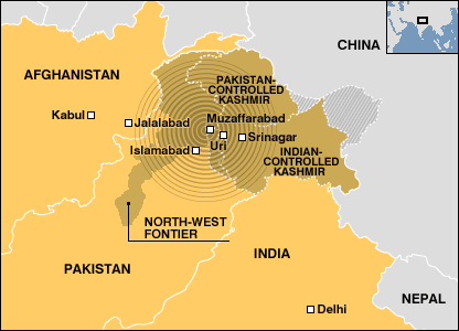
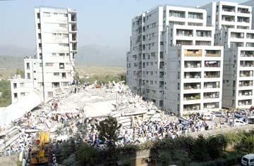
During the course of the year, other disasters took their toll too. Most devastating of them: Hurricanes Katrina and Rita on the South-East coast of the USA; and another enormous earthquake near Pakistan's border with India.

These disasters took their immediate toll, and, each time, the world tried to help. But as calamity piled upon calamity, there has been a certain amount of fatigue. Perhaps people's stock of goodwill has run low. Perhaps seeing too much suffering hardens us.

But, the fact is, the suffering from those disasters has not ceased. Parts of South Asia have still not recovered from December 26th, 2004. In the USA, normalcy hasn't returned to New Orleans. In Pakistan, thousands are still homeless, and may not survive the harsh Himalayan winter.

They need your help.

Last December and this January, the online community came together as never before to help in the aid efforts in South-East Asia. The lessons learned there were put to use, and improved upon, when the other tragic events of the year unfolded.

Can we harness that goodwill, that togetherness, that willingness to help once more?

The WorldWideHelp group would like you to join us in Remembrance Week. Here's what we suggest you do.

WWH Remembrance WeekUse your blogs, your home pages, your wikis, your newsletters. Link to your favourite charities and NGOs, write a paragraph about them and the work they are doing, and ask your readers to make a donation. (If you'd like to find some more charities and NGOs, please take a look at this page on our TsunamiHelp wiki, this one on our KatrinaHelp wiki, or this one on our QuakeHelp wiki.)

Please link back to this page to help pass the word. You can use the image above.

Please use this Technorati Tag: .
Here's the code:
<a href="http://www.technorati.com/tag/disaster%20remembrance%20week" rel="tag">Disaster Remembrance Week</a>

In this post, we have a few more banners and buttons, with intructions on the code you must post to use them.

Tsunami Anniversary Trek - Thailand

Evelyn Rodrigues, who found herself caught in the tsunamis in Thailand, and had live-blogged her experiences thus bringing the pain and suffering closer to people all over the world, goes back on a Tsunami Anniversary Trek, and once more shares with her readers, a first-hand account of her trip. Worth a read for those interested in looking into the lives of people, their pain, and fears that still haunt them, one year after the terrible disaster.
The Sri Lankan government is to hold a special commemorative program in remembrance of those who lost their lives in the tsunami catastrophe on Dec. 26, Daily News reported Thursday. President Mahinda Rajapakse will attend the event which will also coincide with the launch of the "Jayalanka" program to accelerate rehabilitation of the displaced victims.

A two-minute silence is also to be observed islandwide at 9:30 a.m. local time. During the period, all citizens are requested to stop whatever activity they are engaged in and remember those who lost their lives in the catastrophe and commit their dedication towards rebuilding the nation.


Source: Xinhua via People's Daily Online
Almost a year on and Australian experts are still on the ground in Thailand dealing with the appalling aftermath of the tsunami. The Australian Federal Police forensic team said yesterday another 800 bodies in Thailand are yet to be identified. Many never will be. AFP Disaster Victim Identification teams rushed to Thailand after the waves hit, putting to work their experience gained in identifying bodies in tropical climates during the aftermath of the Bali bombings. Once established, the AFP found itself co-ordinating a crack forensic squad made up of experts from 30 countries.

Though the horrific mess left behind by the tsunami is today in the back of most Australians' minds, the AFP DVI teams are still confronted with the horror on a daily basis, working in conditions that are hot and uncomfortable. The AFP will wind back its commitment to Thailand in February, but only after teaching the Royal Thai Police the latest scientific techniques in identifying bodies. Australia will also leave behind a $50,000 trailer kitted-out with the latest forensic equipment. About 5000 people died in Thailand when the tsunami smashed into the coast on Boxing Day. Read More....


Source: Herald Sun

Discovery Channel's Tsunami Show

Thanks to Maria Park for this useful information:

AMERICA’S TSUNAMI: ARE WE NEXT? follows an international team of 27 scientists, led by Dr. Kate Moran from the University of Rhode Island, as they become the first team to reach the seafloor site of the devastating December 26 Asian tsunami. Using state-of-the-art camera equipment, the special shows never-before-seen footage of the epicenter and the massive and dramatic geologic changes that caused gigantic waves.

AMERICA’S TSUNAMI: ARE WE NEXT? premieres December 18 at 9 PM (ET/PT) on Discovery Channel in US.

Most of Japan's bilateral tsunami aid remains untouched

More than two thirds of the bilateral aid Japan offered after the Indian Ocean tsunami remains untouched, raising questions on whether the massive assistance met victims' needs, a report said Monday. Japan was one of the biggest donors amid the outpouring of global sympathy following the Dec. 26, 2004 tsunami, disbursing US$ 500 million to governments of affected countries and international aid groups.

But nearly 70 percent of the 24.6 billion yen ($204 million) in bilateral aid to Indonesia, the Maldives and Sri Lanka remains unused nearly a year later, the Asahi Shimbun reported. Indonesia, the biggest aid recipient at 14.6 billion yen, did not start using the money until May 4 and as of Nov. 10 had withdrawn only 15.8 percent of the funds, the newspaper said.

Japan, the world's biggest aid donor in dollar terms after the United States, usually offers low-interest loans rather than grants and attaches the money to specific projects. But after the tsunami, Japan broke with its usual practice by giving cash handouts and letting governments choose what to spend the money on, although their plans still had to be approved by Tokyo. By contrast, Japan offered $20 million in aid after Kashmir's earthquake in October.


Source: The Jakarta Post
Just under half a million Sri Lankan people were displaced by the tsunami that hit the island's coastline on the morning of 26 December 2004. Nearly a year on, many are still living in refugee camps, waiting for government and aid agency help to rebuild their homes. They have been told they may have to stay in transitional shelter for up to three years, while the estimated 100,000 homes to house them are built.

Save The Children Sri Lanka has funded PhotoVoice, a London non-profit organisation, to run a five-week intensive photojournalism training workshops near Matara, in the island's southern province, to let children document their lives a year after the tsunami. Journalists David Gill and Annie Dare are teaching eight children between the ages of 12 to 18 from the coastal village of Kamburagamuwa.

Some of the group lost family members, some lost friends, some lost belongings and some lost homes. As the anniversary of the tsunami approaches, each of these children is lucky enough to have a permanent house to call his or her own. For the next fortnight, they are partnering families from the nearby fishing community of Talaramba. Here they are gathering stories from and photographing the daily lives of people forced to live in an overpopulated transitional shelter made of wood and corrugated tar sheets.

In the coming weeks, Annie and David will also be training children living in the transitional camps in photography, so that they too can tell their stories. The next update on the BBC News website will include these pictures. An exhibition of the final body of work will be exhibited in Sri Lanka at the beginning of December and also at Save the Children in London EC1 from 19 December. If you are interested in finding out more about this project or the resulting exhibition please contact anna at photovoice.org


Source: BBC News via ServeSriLanka

Aceh Diary: Blogging from Aceh

Shaela Rahman of the International Finance Corporation has recently moved to Aceh to set up the Private Enterprise Partnership for Aceh and Nias. She has just arrived, but will be blogging on the World Bank's PSD Blog several times a month, sharing her progress and thoughts. Click here to view an introductory post about Shaela and her first blog posting can be found here.

Magnitude 6.5 Quake Hits Off Indonesia

A magnitude 6.5 quake rattled two islands off the coast of Sumatra on Saturday, triggering a tsunami alert and panicking some residents, officials said. There were no immediate reports of damage or casualties. The quake's epicenter was located off Simeulue Island, about 160 miles southwest of Medan on Sumatra's west coast, according to the U.S. Geological Survey. It struck just after 9 p.m. local time.

The island is near the epicenter of the Dec. 26 quake that caused a massive tsunami, killing at least 180,000 people. Indonesia's Meteorology and Geophysics Agency put the magnitude at 6.2, saying it was centered 19 miles under the Indian Ocean seabed, about 40 miles southwest of Sinabang, the main town on Simeulue island.

Rusdi, a resident of Sinabang contacted by The Associated Press, said the quake was felt there, but did not cause any widespread panic in the town. He uses only one name. The quake strongly jolted nearby Nias island and was felt in Medan, said Subagio, an official at the Meteorology and Geophysics Agency's Jakarta office who goes by a single name. Agus Mendrofa, the deputy mayor of Nias, told El Shinta radio station that some people momentarily fled their houses when the temblor struck.

"It was pretty strong because it was the first time in the past months that people ran out of houses because of a quake," Mendrofa said from the island's main town of Gunung Sitoli.

He said he had received no reports of damage elsewhere on the island. Saturday's tsunami alert was issued by the Pacific Tsunami Warning Center in Hawaii.


Source: BBC News | ABC News | CBC

Small Earthquakes Rattle Santa Monica

Two small quakes were felt through the west Los Angeles area on Saturday. The first quake struck at at 1:18 in the afternoon local time and registered 3.1 on the richter scale. The second quake was felt at 8:42 in the evening and has a preliminary magnitude of 3.0.

Quakes of this size are not expected to cause any damage.

The quakes were centered about 7 miles below the surface of Santa Monica. Specific coordinates put the epicenters near Santa Monica airport.

Click on the map to see a detailed picture of the area where these quakes were centered.


the World Wide Help group

Many of the people behind this and similar projects [MumbaiHelp, Cloudburst Mumbai, Katrina Help blog and wiki, Rita Help blog and wiki, South Asia Quake Help blog, wiki and SMS Quake] have got together in a single group.

The idea is that any time there's a disaster, any member of the group can alert the a ready-made team, all of them with experience in the field, enthusiasm and goodwill, and request help to get something going.

Once the actual project takes shape, the individuals involved may decide to form a separate coordination group to run things.

The other part of the agenda is that we can exchange info, learn from the things we did wrong, and get better each time the sad, but inevitable happens.

Group Page:
http://groups.google.com/group/WorldWideHelp

Group description:
General newsgroup and rallying point for power bloggers, wiki experts, database adepts, etc, for calls to action and volunteers to provide information post-disasters.
Will also be used to exchange information in more peaceful times, so we can all learn from our experiences.

Join This Group question:
Please tell us which online relief efforts you have participated in, and your strengths (eg. blogging, wikis, databases, tech innovation, hosting, sponsorship, etc).

Go here to send in a join request.
I have created a special map showing a detailed location of this killer 7.7 earthquake and it's 6.2 aftershock.

We know the earthquake has been felt for many hundreds of miles, however, the most tragic reports are coming out of the small villages near the epicenter.

This map shows the distances between nearby small towns and the 7.7 earthquake.

CLICK HERE TO SEE THE MAP

For fresh updates on the 8th October earthquake

For fresh updates on the 8th October earthquake, please visit us at http://quakehelp.blogspot.com/, where the team has duplicated the information posted here so far.

We will now be posting exclusively to the new blog, http://quakehelp.blogspot.com/. Please send the link to your friends, and let us know if you'd like to help.
Abbottabad and areas around faced a heavy eartquake (7.6) at 8:42 AM today the 8th September 2005 which resulted in damage to many buildings and have claimed many lives in Abbottabad, Mansehra, Balakot, Garhi Habibullah, Muzafarabad and areas north to this region.

All hospitals in the region are on Red Alert receiving victums of the quake. More than 200 patients have been treated in Ayub Teaching Hospital till now (3:30 PM)

The Surgery Paper B of Final Year MBBS has been posponed while the rest of the examination will be on schedule. The College will remain closed till further order. The hostels have been evacuated as a precaution. For more information please email, call +92-(992)-381907 or send a fax to +92-(992)-382321


Source: Ayub Medical College
Lying on makeshift beds on a hospital lawn in this northwestern Pakistani hill town, some screaming in pain, hundreds of men, women and children wait for help. But they have to stay there for now, because doctors say the monster earthquake that rumbled through the region early Saturday could have made the building dangerous.

"We feel it is unsafe to keep patients inside," Amir Shah, a senior doctor at the Ayub hospital in Abbotabad, told AFP.

Already at breaking point because of the flood of victims and a shortage of supplies, vilent aftershocks added to the worry.

"Our doctors and paramedical staff are scared to go in. The building has already developed cracks," Shah said.

Abbotabad is on the road towards the epicentre of the quake and is just miles (kilometres) from the worst affected area, where thousands of people are feared to have died. In the nearby districts of Mansehra and Malakand in North West Frontier Province police said the up to 600 had perished, while Pakistani-controlled Kashmir was thought to have suffered even bigger casualties. Some of the injured interviewed by AFP at Ayub hospital said they saw entire villages razed.

"I was working in the field close to a building when I felt the jolt and saw houses tumbling down to the ground," one of the injured, Wali Rehman, from Ugi village in North West Frontier Province, told AFP.

"I know my mother and my family have died," he said, weeping.

Another victim from near Balakot town in Kashmir said at least 200 homes in his village were flattened. "It was complete devastation all around," Jehanzib Khan told AFP.

As ambulances and vans continually ferried injured people to the hospital, the lawn became more crowded with patients. A hailstorm as night fell a hailstorm added to their discomfort. Dozens of people, mainly workers from the local Al-Khidmat private aid service, had gathered at the hospital, trying to arrange medicines, food and blood for the injured. They also brought food for victims to break their fast as the third day of the Muslim holy month of Ramadan came to a close. But doctors feared they have only treated a fraction of the victims from the earthquake. Many affected areas have been cut off by landslides and it will take people hours or even days to get to Abbotabad.

"We need medicines, blood and equipment to treat the stream of wounded people," said doctor Nadeem Gohar.


Source: ReliefWeb
The South Asia quake struck just before 6 o'clock in the morning Central European Time, and was just 10 kilometres deep. It was followed by a series of strong aftershocks. It is reported that several villages close to the epicentre of the quake have been totally destroyed. In Islamabad, scores of people were feared killed or trapped in two 12-storey apartment blocks that collapsed.

In Afghanistan, authorities say apart from the death of a young girl when a wall collapsed, and some damage to buildings, the country appeared to escape the worst of the quake. Deaths have been reported in many outlying areas in Pakistan, but so far there is no official tally. Hospitals have been inundated with scores of people who have been injured.


Source: EuroNews

From the BBC here, as part of this report.
The United Nations is ready to assist the victims of the earthquake which occurred on 8 October in Northern Pakistan, also affecting neighbouring countries of India and Afghanistan.

“ We are in contact with the Governments of the countries affected. OCHA stands ready to dispatch an United Nations Disaster and Coordination Team (UNDAC) to help assess the damage and coordinate the response in Pakistan”, Under-Secretary-General for Humanitarian Affairs and Emergency Relief Coordinator, Jan Egeland said today.

In Geneva, an UNDAC team is on stand-by ready to be deployed at the request of the Government of Pakistan. An aircraft has been made available by the Government of Switzerland to fly directly to Islamabad later today.

In Pakistan, damage to buildings and houses have been reported in Islamabad. More severe damage is being reported in Muzaffarabad, Rawalpindi, Lahore and Peshawar. It is anticipated that the death toll might be severe.

The high intensity of the earthquake in Pakistan was also felt in Afghanistan and across northern India. In India, where buildings have collapsed, official reports confirm the death of more than 200 people and more than 400 injured. There is minor damage in Afghanistan where two people are reported to have been killed.


Source: ReliefWeb
Srinagar, Oct 8.(PTI): About 250 people, including 25 security personnel, were killed and 650 others injured in a powerful earthquake that rocked Jammu and Kashmir this morning leaving a trail of devastation.

Hundreds of houses and other buildings collapsed or were damaged in the tremor, which was the strongest in over 120 years, and was followed by over a dozen aftershocks that triggered panic in the area.

Official sources said the death toll was continuously mounting as reports have started pouring in from far off places which got cut off from the mainland due to the earthquake.

Baramulla district of North Kashmir was the worst hit where 142 people died especially in the border town of Uri where a number of villages near the Line of Control almost got flattened.

Read teh Full Story at The Hindu
The bodies of at least 250 children have been pulled from the rubble of a school destroyed by the powerful earthquake in north-west Pakistan.

Police chief Riffat Pashar told Reuters news agency 350 altogether had died in the collapse in Mansehra district.

"Fifty were killed in another school in the same district," he said. There is no confirmation.

More than 2,000 people are feared dead from the 7.6-magnitude quake that hit Pakistan, India and Afghanistan.

The earthquake, which was registered at 0350GMT, was felt as far away as the Afghan capital, Kabul, and India's capital, Delhi.

Read the Full Story at BBC News
Despite reeling under the aftermath of the devastating earthquake, India on Saturday offered rescue and relief assistance to neighbouring Pakistan, parts of which also suffered extensive damage in the natural calamity.

Prime Minister Manmohan Singh in a message to President Pervez Musharraf said, "while parts of India have also suffered from this unexpected natural disaster, we are prepared to extend any assistance with rescue and relief which you may deem appropriate".

He expressed distress at the extensive loss of life and property in Pakistan as a result of the natural disaster.

The prime minister conveyed condolences to those who have been bereaved in the tragedy.

In another message, External Affairs Minister K Natwar Singh conveyed to his counterpart Khurshid M Kasuri profound sympathy to all those who have lost their loved ones and those who have been injured in the quake.

"Please do not hesitate to indicate to us in whatever way we can be of some assistance both for rescue and relief in the affected areas," he said.

Foreign Secretary Shyam Saran spoke to his Pakistani counterpart for the first time over the hotline activated recently to convey sympathy over the tragic loss.

Soure: Rediff.com
Médecins Sans Frontières (MSF) has a staff of three who recently arrived in the Pakistani area to start a project on safe motherhood. The focus now is to mobiize more staff and supplies to the region. An earthquake measuring 7.6 on the Richter Scale struck in the north of Pakistan this morning, just 80 kms north of the Pakistan capital, Islamabad. The affected area runs from the north of Afghanistan and Pakistan to the Indian Kashmir.

MSF was already present in the area with three expats in the village of Lamnian in Pakistani Kashmir, some 15 kilometers from the line of control with Indian Kashmir and close to the epicentre of the earthquake. The three are a project coordinator, logistician and nurse and were about to start a project there and were hiring national staff.

The village has been completely destroyed, including the clinic where we are about to start working and the MSF house. The project would focus on safe motherhood. All team members are fine. The Pakistani army is responding with big logistical/medical capacity

MSF is now focusing to getting reponse capacity to the region. Stocks from Quetta, Dubai and Mumbai will be moved up to the north and MSF is looking into how to get additional resources in the country; cargo as well as people (blankets; jerrycans; sleeping mats and tents)


Source: ReliefWeb
ISLAMABAD, Oct 8 (Reuters) - Strong aftershocks rattled the capitals of Pakistan, India and Afghanistan on Saturday afternoon, hours after a deadly quake shook the south Asian subcontinent.

Reuters correspondents in Islamabad, New Delhi and Kabul all reported feeling a strong aftershock at around 1045 GMT -- nearly seven hours after the main quake which was centred around 95 kms (60 miles) northeast of the Pakistan capital.

Pakistan officials say whole villages have been flattened by the quake and they fear thousands of casualties.

Source: Reuters AlertNet
Czech rescuers are prepared to go to the south Asian regions badly hit by an earthquake today, spokesman of the Czech Fire and Rescue Corps Petr Kopacek and spokesman for the Hand for Help humanitarian organisation Jana Eichlerova said.

The rescuers are only waiting for an official request from local authorities. The firefighters are able to prepare their rescuer team within 24 hours and rescuers from Hand for Help are also capable of leaving for the region at the same time, they said, adding that money-raising campaigns have been launched already.

"We don't know yet what the Pakistani government requests and what it will need. We don't know whether they want foodstuffs or a special team," Kopacek said. He said that the rescuer and reconnaissance team which also includes dog-handlers, could be prepared to leave within 12 or 24 hours. Hand for Help, which organised help in Southeastern Asia which was hit by a devastating tsunami last year, is also waiting for an official request from Pakistani authorities.

Director of the Czech ADRA Jan Barta said that his organisation was collecting the first information and would organise a money collection if need be. Czech Catholic Charity is also prepared to start a collection on the Internet, its spokesman Jan Oulik said.


Source: CTK
The disaster management cell at the Indian Home Ministry Control room telephones:

91 (011)-23093563
91 (011)-23093564
91 (011)-23093566
8 October 2005 – Following a massive earthquake in Pakistan that affected also Afghanistan and India, the United Nations is working with the governments of those countries on an emergency response.

The UN Office for the Coordination of Humanitarian Affairs is exploring “ways in which the United Nations can assist in all efforts required to support relief and rescue operations and in subsequent recovery and reconstruction,” a spokesman for Secretary-General Kofi Annan said in New York.

The spokesman said Mr. Annan is “deeply saddened by the loss of life and destruction” caused by the quake, which had a magnitude of 7.6 and struck 95 kilometres outside of Islamabad.

Source: UN News Centre
A strong earthquake of magnitude 7.4 occurred on 8th October 2005 at 8.50.38 AM (local time) with epicenter at 34.432°N, 73.537°E in Muzaffarabad Region of Pakistan lasting for 6 minutes. The depth of the earthquake was at 10 km with preliminary location at 93 km from Islamabad, Pakistan, 114 km from Mingaora, Pakistan and 124 km from Srinagar, Kashmir. Subsequent after shock tremors of 5.9, 5.6 and 5.2 and 6.0 magnitude at intervals were recorded in the same region of Kohistan region i.e 65 km east of Mingaora, Pakistan and 172 kms North West of Srinagar (Jammu & Kashmir), India.

The high intensity earthquake was felt in part of Afghanistan and across northern India covering states of Jammu, Kashmir, Uttaranchal, Delhi, and Punjab, Himachal Pradesh, Rajasthan, Haryana, Uttar Pradesh at 9.25 a.m. IST on 8th October 2005. The worst affected districts in Jammu and Kashmir due to impact of the high magnitude earthquake are districts of: Poonch, Baramulla , Jammu, Udhampur, Ramban Kathus, Srinagar, Budgam, Anantnag, Pulwama and Kupwara.

Location 34.748°N, 73.141°E
Depth 10 km (6.2 miles)
Region PAKISTAN
Distances 71 km (44 miles) E (93°) from Mingaora, Pakistan
120 km (75 miles) N (0°) from ISLAMABAD, Pakistan
164 km (102 miles) SE (139°) from Chitral, Pakistan

Preliminary Location
4.0 kms SE of Ghori, POK
10.7 kms ESE NNE of Muzaffarabad, POK,
32.9 kms ENE of Manshera, Pakistan,
60.9 kms NW of Uri (Jammu & Kashmir), India,
90.2 kms NNE of Islamabad, Pakistan,
123 kms WNW of Srinagar (Jammu & Kashmir), India,
326 kms NNW of Lahore (Punjab), Pakistan,
740 kms NW of Delhi (NCT), India.

Damage Details:

Pakistan: Strong tremors were felt in northern Pakistan, rocking buildings in the capital Islamabad
Muzaffarabad, Rawalpindi, Lahore, Peshawar. Reports of server damage to buildings, houses and
casualties of injured residence and death toll risen to 1000 people have been reported from Islamabad,
Muzaffarabad, North West Frontier Province(NWFP) and Lahore districts. Army and the state
administration are conduction rescue and relief operations.

Jammu Kashmir, India:

Official reports confirm death of 213 people (Srinagar, Baramulla and Kupwara, Uri, Poonch,
Udhampur and Doa districts) , including 16 army personnel, in Jammu & Kashmir and death of
1each in Gurdaspur and Batala districts, Punjab.

385 people have sustained injures due to collapse of building walls in Paraypora, Poonch,
Baramulla, Srinagar and Anantnag districts while 7 buildings were damaged in Amristar,
Hoshiarpur, Moga, and Gurdaspur in Punjab state.

Preliminary assessment state damage to 963 masonry buildings (houses, buildings) reported
from Uri, Baramulla and Sopore towns of Baramulla district and in Srinagar, Anantnag,
Baramulla and Kupwara districts .

Incidence of fire reported in parts of Baramulla district while Moti Mahal Fort in Poonch district
and Reasi Fort in Reasi district have sustained damages. People in the affected districts
panicked and came out their homes after shock tremor felt at 4.15 IST.

Communication network, infrastructure facilities and traffic has been disrupted on the National
Highway 1A between Srinagar-Muzaffarpur and Boniyar due to landslide triggered by the
earthquake.

Administrative Measures:

The affected district administration are being assisted by the army and air force to conduct
rescue/search and relief operations in Uri, Tangdhar, Baramulla and Kupwara sector, while
essential supplies, including power, water and telecommunication are being restored .

The personnel have evacuated injured persons to Uri Field Hospital. Makeshift hospitals are set
up and doctors were being flown to Uri to attend to the injured.

The Home Secretary Government of India has taken stock of the situation with the Chief
Secretary of Jammu and Kashmir .Also the secretaries of Central ministries/departments have
been requested to extend emergency support.

Prime Minister of India is closely monitoring the situation and announced an ex-gratia amount
of Rs 1000,000 to persons dead and assured all possible Central assistance to the state.

For Further Information:

G Padmanabhan
Emergency Analyst, UNDP
E-mail: g.padmanabhan@undp.org,
Mobile: 91 -- 98104 02937
http://www.undp.org.in/dmweb/

Source: ReliefWeb
Oxfam has just coordinated a meeting in Islamabad of all of the international aid agencies responding to the earthquake.

At that meeting it was agreed which organisation would be leading in which area to ensure a coordinated response.

Teams from each of the agencies are leaving on assessment and response missions, some have already left and in the next few hours more will be
dispatched.

It is becoming clear that the most affected area is Pakistan administered Kashmir where 5 out of 7 divisions are severely affected. Oxfam has started an assessment in 3 of these 5 areas with teams already on the ground. Winter is drawing in in the region and night time temperatures are already dropping. Winterised tents and blankets will be urgently needed.

Read the Full Story at ReliefWeb
Jakarta, Oct. 8 (AP): A strong earthquake rocked parts of Indonesia's tsunami-ravaged Aceh province today, causing panic among residents, official and witnesses said. There were no immediate reports of damage or casualties.

The magnitude 5.8 earthquake struck near southern Aceh's Singkil town and its surrounding areas at 11:30 am (1000 IST), said Muslih, an official at the Meteorology and Geophysics Agency.

Muslih, who uses one name like many Indonesians, said the quake strongly jolted Singkil, but so far there were no reports of its effects.

Andayani, an official at the local district office, said many panicked city-dwellers ran out of their houses when the quake struck.

Read the Full Story at The Hindu
Srinagar, Oct. 8 (PTI): The earthquake that shook Jammu and Kashmir today was the severest in the state in over 120 years, a senior officer of the weather office said.

Our records show that an earthquake of 7.0 magnitude was felt in the valley with epicentre at Sopore in Baramulla district of North Kashmir on May 30, 1885, Director, Weather Office, G K Mohantey, told PTI here.

He said although Jammu and Kashmir usually witnessed moderate to severe earthquakes in the past as well, today's tremor was the severest.

Mohantey said today's earthquake had the magnitude of 7.4 on the Richter scale and its epicentre was at a place near Muzaffarabad in Pakistan at latitude 30.6 degrees north and longitude 73.0 degrees east.

Read the Full Story at The Hindu
Boniyar (J & K), Oct. 8 (PTI): The Army has seized Uri and barred media from entering the town of Baramullah district in Jammu and Kashmir even as the injured were being evacuated hours after the 7-plus magnitude earthquake flattened it this morning.

Survivors of the giant quake said in this hamlet, 20 km from Uri, that the death toll was "much higher" and the entire town had been flattened.

They complained that the relief and rescue efforts had not come speedily and were not enough.

Source: The Hindu
New Delhi, Oct 8. (PTI): After the massive earthquake that killed hundreds of people in Jammu and Kashmir and Pakistan today, strong aftershocks continued to rock the region with the Met department warning of more in the next several days.

Seven aftershocks measuring over 5.0 on the Richter scale were recorded after the temblor measuring 7.4 rocked the region at 0920 hrs IST. All were epicentred near Muzaffarabad in Pakistan-occupied Kashmir.

The strongest of these was a 6 magnitude jolt recorded at 1616 hrs and several smaller ones were felt through the day.

A Met official said aftershocks were a normal phenomenon after a major earthquake and these were likely to continue for several days.

However, no warnings were being issued as it was not possible to predict the timing of the aftershocks, he said.

Today's temblor was one of the strongest recorded in the region in recent times.

Source: The Hindu
There's an urgent call for medical assistance in Mansehra, 50 kilometer north of Islamabad. A german-based medical ngo - Humedica International has just sent in their first team into Pakistan. They are deploying mobile relief hospitals and working with a local ngo in the area - PAK relief to assist 3,000 displaced persons in the area - intially.

Humedica International is calling for certified medical volunteers to join their team, download the volunteering form from here. You may also get in touch with Joerg Eich at +49-8341-9661480 or email j.eich@humedica.org

Image Courtesy: BBC News
ISLAMABAD, Oct 8 (Reuters) - A major earthquake shook cities and villages across the south Asian subcontinent on Saturday, "wiping out" several villages in Pakistan and leading to fears that the death toll could run into thousands.

Officials said heavy damage was expected in northern Pakistan, but details were difficult to obtain because telephone lines were down and mobile networks overwhelmed.

"The deaths could be running in the thousands. We do not have an exact figure for casualties at this moment, but it's massive," President Pervez Musharraf's spokesman, Major-General Shaukat Sultan, told Reuters following a aerial survey of stricken areas.

The earthquake, with a magnitude of 7.6, struck at 0350 GMT and was centred in forest-clad mountains of Pakistani Kashmir, near the Indian border, about 95 km (60 miles) northeast of Islamabad.

Source: Reuters AlertNet
At least dozens of women workers of a textile mill wounded in stampede created when a strong quake hits Kharianwala, Faisalabad.

The injured were rushed to Kharianwala social security hospital where a woman reported in critical state. People still gathering in open areas and grounds due to quake fear.

Source: The Nation

Image Courtesy: AFP/Getty Images
Pakistan says more than 1,000 people may have died in a powerful quake that also hit north India and Afghanistan.

The quake with a magnitude of at least 7.6 had the epicentre 80km (50 miles) north-east of Islamabad.

At least 500 died in North-West Frontier province in Pakistan and 1,700 were injured. In Indian-administered Kashmir, 200 are confirmed dead.

Rescuers are trying to reach dozens of residents feared trapped in a building that collapsed in Islamabad.

Source: BBC News

Massive tremors rock north India

Massive tremors rocked North India at 9.25 AM on Saturday morning. Tremors measuring 6.8 on the richter scale were felt in Delhi, Srinagar, Amritsar, Patiala, Jaipur, Chandigarh and Dehradun. The quake had its epicentre in Pakistan.

Immediate reports from Jammu & Kashmir say that normal life has been disrupted. Communication lines have been disconnected. People have left their houses and taken refuge under the open sky.

The tremors went on for about thirty seconds and are reported to have also been felt in neighbouring Pakistan and Afghanistan.

Local television in Pakistan said the quake caused panic in Islamabad, as well as nearby Rawalpindi, Lahore, Peshawar and Quetta near the Afghan border.

Source: Rediff.com

Duelling agencies hurt tsunami relief

The tsunami which devastated Aceh on Dec. 26, 2004, left 164,000 people dead or missing and over 400,000 homeless. It rapidly became the most reported and well-funded disaster in history. Over 200 humanitarian organizations — plus 3,000 military troops from a dozen countries — arrived to offer aid.

Neighbouring countries were quick to respond. Language and culture proved no obstacle to their teams, which swiftly grasped immediate needs. Yet many international agencies brought in staff from Europe or America, when they could have exploited regional expertise.

Although international agencies were right in guessing that water, food and shelter would be survivors' initial needs, they were wrong to assume these needs would not be covered, at least partially, by Indonesians themselves. Agencies did little to suppress the myth of disaster victims dependent on external aid to survive. At the root of co-ordination problems was one key factor: too much money. Read More....


Source: The Toronto Star

Palm Springs Quake Falsely Reported

The Associated Press released a news story stating that a 3.2 magnitude earthquake occurred 13 miles north of Palm Springs on Sunday September 25. The fact of the matter is that no such quake occurred.

What did happen was what is called a "teleseism". Teleseisms are seismic waves caused by distant earthquakes. In this case, the teleseisms were caused by the 7.5 earthquake in Peru, which occurred several minutes before the teleseisms arrived in Southern California.

The Southern California Seismic Network's automatic earthquake detection system mistakenly thought the waves were those of a small local quake. Those who have pagers connected to the SCSN (Caltech/USGS employees, first responders, utility companies, and media) received a page (or automatic email) for a M3.2 quake near Desert Hot Springs at that time. As it turns out, the SCSN Duty Seismologist removed the event from the Simpson Map (the California earthquake map).

All earthquakes that occur are reviewed by a human. The automatic detection system is not perfect and sometimes mis-reports earthquakes.

Associated Press writers released this story without confirming that a quake actually occurred.

The quake in question was removed from the system within just a few minutes. Yet the news story lives on. Still, no reports of damage or injuries....
The earthquake that occurred 18 miles North of Tehachapi, California on September 24th has been upgraded from a magnitude of 3.5 to 3.6.

This is not a significant change. The adjustment came after several standard reviews. Many adjustments to magnitude, depth, location and time of occurrence, are made to all earthquakes. Reviews and adjustments can go on for days, weeks and sometimes months, depending on the size of the quake.

This earthquakes depth was also adjusted from 6.3km to 6.0km.

India to have tsunami warning system by 2005

The country has approved setting up a tsunami warning system in the Indian Ocean at a cost of Rs 125 crore, a former official of the Ocean Development department said on Friday.India has decided to set up the Indian Ocean Global Ocean Observation System (IO-GOOS) connecting all seismic stations to share tsunami related information, former Secretary of the department Dr Harsh K Gupta said. Pointing out that it was essential to record occurrence of a tsunami, Gupta told an international seminar on 'Natural Hazards - Disaster Mitigation' that sensors would be planted at the bottom of the Indian Ocean by September 2007. Read More ....


Source: Press Trust India via HindustanTimes

4.7 Earthquake Shakes the Mettler Area

A moderate 4.7 earthquake shook the Mettler California area on September 22. The quake was felt as far away as Orange County to the South and Fresno to the North. The quake caused minor merchandise damage to some local shops, but no injuries were reported.

A 3.4 foreshock preceded the 4.7 mainshock by forty-four seconds. A robust aftershock sequence followed. Eight aftershocks above 3.0 were recorded within 14 hours.
Earthquake Map - Mettler, CA

This particular area is known to have earthquakes on occasion. Earlier this year A 5.2 earthquake and a 4.1 quake struck an area about 10 miles west of this current sequence.

In 1952 the Kern County 7.5 Quake was centered less than five miles from the location of this quake.

Small Quake Rattles Santa Cruz Area

SEPTEMBER 18, 2005

An earthquake with a preliminary magnitude of 3.1 rattled a section of California south of San Francisco. The quake was located between Santa Cruz and Menlo Park near the small community of Boulder Creek. The quake struck just after midnight.

Although the quake was small it was felt by many people. Within two hours over one thousand people have reported feeling the quake. Reports have come in from as far north as San Francisco and as far south as Santa Cruz.

A quake of this size is not expected to cause major damage or injuries.

Strongest shaking was felt around the Boulder Creek area. One local resident was quoted as saying "set things to swinging and rattled with windows/glasses."

The deadly 7.0 Loma Prieta earthquake struck this region during the evening of October 17, 1989. That quake was centered 9 miles northeast of Santa Cruz, or 18 miles southeast of this recent quake.

The map below (click for full size) shows where this quake and it's first five small aftershocks occurred in relation to boulder Creek.


Slow Seismic Slip Event Underway in Pacific Northwest


An important seismic event imperceptible to humans has begun in the Pacific Northwest as predicted, according to the government agency Geological Survey of Canada.

The chance of a major earthquake is 30 times higher now for a roughly two-week period, but the odds are still remote, scientists say

continue...

SPECIAL REPORT: Fontana, CA

Late in the evening of September 6, 2005 we have seen a small swarm of earthquakes developing around the Fontana area.

1.3 2005/09/06 11:52 PM ( 2 mi) NW of Loma Linda, CA
1.0 2005/09/06 11:03 PM ( 4 mi) NNE of Fontana, CA
1.2 2005/09/06 10:56 PM ( 4 mi) NNW of Rialto, CA
1.2 2005/09/06 10:20 PM ( 2 mi) WSW of Loma Linda, CA
2.0 2005/09/06 10:09 PM ( 4 mi) NNE of Fontana, CA
1.0 2005/09/06 10:08 PM ( 4 mi) NW of Rialto, CA
1.2 2005/09/06 9:53 PM ( 4 mi) NW of Rialto, CA
1.4 2005/09/06 9:39 PM ( 4 mi) NNE of Fontana, CA

Do these small quakes mean a larger one is on the way? I did some research and I will present my findings and let you decide for yourself whether these are foreshocks are just another small swarm.

I searched past earthquakes which have occurred within 10km of this current activity.

Since 1950 there have been 17 earthquakes of 3.5 or greater. Seven of these had at least one foreshock.

Here is a map showing the specific location we are talking about. Quakes shown on the map come from the list below:


Mainshocks are listed in BOLD

3.9 5/15/1955 5:03 PM

4.1 6/28/1960 8:00 PM

3.8 8/21/1960 11:07 PM

3.7 2/25/1965 11:21 AM

3.7 9/2/1966 11:06 AM

3.6 10/14/1967 12:36 AM

3.5 3/17/1975 12:13 AM


1.9 1/7/1983 5:01 PM
2.7 1/8/1983 6:29 AM
4.0 1/8/1983 7:19 AM

1.6 2/18/1987 12:52 AM
1.4 2/18/1987 4:03 AM
1.7 2/21/1987 5:19 AM
4.0 2/21/1987 11:15 PM

1.2 10/11/1997 2:26 AM
1.5 10/11/1997 11:16 AM
1.1 10/13/1997 11:51 AM
3.9 10/14/1997 10:31 PM

1.4 11/1/1997 11:32 AM
3.6 11/4/1997 2:36 PM

0.9 1/29/1999 2:53 AM
3.6 1/30/1999 11:24 PM

3.5 4/9/2000 6:52 AM

3.7 7/25/2002 12:43 AM


1.4 7/26/2004 6:32 AM
3.8 7/28/2004 8:19 PM

1.6 1/2/2005 12:19 PM
1.4 1/2/2005 8:34 PM
1.1 1/2/2005 9:51 PM
1.1 1/2/2005 10:01 PM
1.5 1/2/2005 10:53 PM
2.7 1/4/2005 8:21 AM
1.6 1/4/2005 8:21 AM
1.8 1/4/2005 8:49 AM
3.1 1/4/2005 8:49 AM
1.1 1/4/2005 9:31 AM
1.3 1/4/2005 8:25 PM
1.6 1/5/2005 2:12 PM
1.6 1/5/2005 2:26 PM
2.5 1/6/2005 12:11 PM
3.6 1/6/2005 12:11 PM
2.5 1/6/2005 12:32 PM
3.3 1/6/2005 2:22 PM
4.4 1/6/2005 2:35 PM

Steps to Building A Personal Emergency Plan

Before you begin, take a few moments to consider the possible emergency situations or potential disasters you could face. These are situations and events that could impact you, your family or your neighborhood or community. Talk to your family members to get their views and assistance in building an action plan you and your family can follow to help reduce the possible effects of any emergency or disaster. You may want to consider helping your neighbours do the same, especially those who are elderly or disabled.

The following steps will help you develop a personal or family emergency plan:
MORE....
I have uploaded the 2004 earthquake maps. You can access them using the menu on the right sidebar.

I have decided to put the map and the list on the same page. The list appears below the map. Hopefully this will make it easier to view the data.

If you have any problems viewing or accessing the maps please leave a comment or send me an e-mail.

Obsidian Butte: Swarm Update

UPDATED: 9/5/05 - 3:00 AM

NEXT UPDATE: 9/10/05 (unless there is a significant increase in activity)

NOTE: This report focuses on a very small radius (20km) around Obsidian Butte and does not include the entire Brawley Seismic Zone.

CURRENT SWARM STATS:
Total Quakes (8/25 - 9/5 2:15am) = 626

dates
8/25 = 1 quake
8/26 = 0 quakes
8/27 = 0 quakes
8/28 = 8 quakes
8/29 = 15 quakes
8/30 = 2 quakes
8/31 = 220 quakes
9/1 = 251 quakes
9/2 = 80 quakes
9/3 = 34 quakes
9/4 = 11 quakes
9/5 = 4 quakes (preliminary)
These quake counts are likely to change with time as USGS officials manually review seismographs.

magnitudes
0.1 - 0.9 = 2 quakes
1.0 - 1.9 = 426 quakes
2.0 - 2.9 = 165 quakes
3.0 - 3.9 = 25 quakes
4.0 - 4.9 = 7 quakes
5.0+ = 1 quake


Obsidian Butte is one of several areas in California known for its earthquake swarms. Unlike The Geysers in Northern California and Coso Junction in Central California, Southern California's Obsidian Butte is sporadic and inconsistent with its swarming. While the other swarm areas rarely see days without quakes, Obsidian Butte can go months without registering a single quake. But when they come, they come in a big way. However, when the quakes do come, they come in volume and not strength.

Obsidian Butte is not known for producing large destructive quakes. Obsidian Butte has seen thousands and thousands of quakes over the years (nearly 10,000 since 1960). However, since 1900 there has only been a handful of quakes that have been stronger than a 5.0. The largest being a 5.8 in 1981. That was also the last time a 5.0 or larger quake was centered in the vicinity of Obsidian Butte.

HERE is a map
showing all 5.0+ quakes that have occurred near the Salton Sea since 1900. On the map you will notice that there are just a few quakes in the immediate area of Obsidian Butte. All Obsidian Butte swarms occur tight against the South-East shoreline of the Salton Sea.

This swarm is following a classic pattern. Reviewing past swarm data shows that this one is making a run to be one of the strongest in many years.

we have seen some impressive swarms since 1960. Here is a list of the most active months (minimum of 50 quakes):

APR 1981: 1250 quakes
SEP 2005: 380 quakes (preliminary)
AUG 2005: 285 quakes (preliminary)
MAR 1989: 248 quakes
NOV 1976: 239 quakes
MAY 1981: 184 quakes
JUN 1979: 169 quakes
NOV 1987: 162 quakes
JUL 1987: 152 quakes
MAY 1983: 130 quakes
OCT 1999: 112 quakes
MAY 1996: 107 quakes
OCT 1979: 105 quakes
JAN 1998: 94 quakes
APR 2003: 88 quakes
MAY 2000: 86 quakes
JUN 2000: 83 quakes
MAR 2004: 77 quakes
JUL 1983: 76 quakes
AUG 1996: 75 quakes
FEB 1989: 69 quakes
DEC 1997: 67 quakes
DEC 1988: 58 quakes
AUG 1986: 56 quakes
OCT 1988: 54 quakes
FEB 2002: 53 quakes
OCT 1995: 51 quakes
JUL 1992: 50 quakes
SEP 2003: 50 quakes


April 26, 1981 was most likely the most active day for swarm quakes at Obsidian Butte. 609 earthquakes were recorded on that day. This day also saw the strongest swarm related earthquake which was a 5.8.

Interestingly there has only been three, maybe four quakes above 5.0 at Obsidian Butte since 1900. We have already talked about the largest, a 5.8 on April 26, 1981. The others were a 5.1 on November 4, 1976 and a 5.5 on July 29, 1950.

The 5.1 in 1976 was also in the middle of a swarm. That particular swarm started at 04:57 with a 2.6 quake. The 5.1 occurred at 10:41 and was the 42nd quake to occur in the sequence. This 1976 swarm died out by the end of November with a total quake count of over 200.

Here is a list of all Obsidian Butte quakes with a magnitude of 4.0 or higher. There really isn't very many considering Obsidian Butte has been the host to nearly 10,000 earthquakes since 1960.

5.8 4/26/81
5.1 9/1/2005
5.1 11/4/76
4.7 10/16/99
4.6 8/31/2005
4.6 3/6/89
4.5 9/1/2005
4.5 8/31/2005
4.5 10/16/99
4.5 8/31/2005
4.4 8/31/2005
4.4 7/13/83
4.4 11/4/76
4.3 8/31/2005
4.2 11/4/76
4.2 11/4/76
4.2 10/27/63
4.2 10/19/88
4.1 8/31/2005
4.1 6/13/79
4.1 11/4/76
4.1 11/4/76
4.1 11/4/76
4.1 11/4/76
4.0 12/31/97
4.0 4/26/76

CURRENT SWARM REPORT
This report will be updated periodically to reflect new quakes. The map below (click for larger view) shows only quakes from this current swarm. These quakes will not be added to the main maps and lists until their magnitudes and locations have been reviewed and updated.


CURRENT OBSIDIAN QUAKES OF 3.0 AND GREATER
click here to see all quakes

3.7 9/5/2005 1:53 AM 1E Obsidian Butte, CA
3.0 9/3/2005 4:17 AM 1ENE Obsidian Butte, CA
3.4 9/1/2005 11:44 PM 1ENE Obsidian Butte, CA
3.3 9/1/2005 8:55 PM 3SSW Obsidian Butte, CA
3.3 9/1/2005 8:54 PM 2SSW Obsidian Butte, CA
3.1 9/1/2005 8:50 PM 1SW Obsidian Butte, CA
3.2 9/1/2005 8:46 PM 2SW Obsidian Butte, CA
3.7 9/1/2005 7:46 PM 1SSW Obsidian Butte, CA
3.0 9/1/2005 6:38 PM 1SSW Obsidian Butte, CA
3.8 9/1/2005 6:30 PM 2WSW Obsidian Butte, CA
5.1 9/1/2005 6:27 PM 1S Obsidian Butte, CA
4.5 9/1/2005 6:27 PM 0NE Obsidian Butte, CA
3.0 9/1/2005 6:23 PM 2E Obsidian Butte, CA
3.2 9/1/2005 7:06 AM 3NE Obsidian Butte, CA
4.4 9/1/2005 6:50 AM 1NNE Obsidian Butte, CA
3.6 9/1/2005 6:50 AM 0E Obsidian Butte, CA
3.5 9/1/2005 6:48 AM 1E Obsidian Butte, CA
3.1 9/1/2005 1:24 AM 1E Obsidian Butte, CA
3.1 8/31/2005 9:15 PM 1ENE Obsidian Butte, CA
4.5 8/31/2005 4:32 PM 3ENE Obsidian Butte, CA
3.4 8/31/2005 4:29 PM 2E Obsidian Butte, CA
4.3 8/31/2005 4:27 PM 3ENE Obsidian Butte, CA
4.1 8/31/2005 4:07 PM 1ENE Obsidian Butte, CA
3.1 8/31/2005 3:59 PM 0ESE Obsidian Butte, CA
3.2 8/31/2005 3:54 PM 1SSE Obsidian Butte, CA
4.5 8/31/2005 3:50 PM 2E Obsidian Butte, CA
4.6 8/31/2005 3:47 PM 1SSE Obsidian Butte, CA
3.5 8/31/2005 3:45 PM 1E Obsidian Butte, CA
3.1 8/31/2005 3:17 PM 1E Obsidian Butte, CA
3.1 8/31/2005 2:49 PM 1NE Obsidian Butte, CA
3.4 8/31/2005 9:18 AM 3ENE Obsidian Butte, CA
3.7 8/31/2005 8:35 AM 2NE Obsidian Butte, CA
3.1 8/29/2005 12:39 AM 4NE Obsidian Butte, CA


Here are some links to articles about the swarm:
Is there a relationship between the Salton Sea earthquake swarm near Obsidian Butte and the hurricane Katrina? (conscious junkyard)

Kate Hutton Earthquake commentary (SCSN)

SCSN Special Report (SCSN)

3.8 Quake Rattles San Diego - Video Footage

A 3.8 earthquake centered along the California and Mexico border just south of San Diego has been felt throughout San Diego county. The quake struck at 11:53 PM on September 2, 2005.

I was able to capture this quake on video. The video clip is not very exciting and not much to see. But I am excited because it has already answered several questions I had. It will help in my research.


This is the first quake to be captured using my new "Klesko Cam". 

Let me take a moment to explain what we are seeing on the video clip. First of all, the quake was heard before it was felt. As the video begins you will hear that I am watching the baseball game. I heard a loud roaring sound coming from outside. I stopped the TV. This is when the sound of the ball game stops. If you have a good sound system with a sub woofer you should be able to hear the deep roaring sound. At the same time you can see Ryan Klesko's head vibrate ever so slightly. Five seconds later the S waves (shear waves) arrived and you can see and hear the small jolt.

The loud whistling/ringing you hear is the quake alarm sounding. The quake alarm is a very sensitive device which detects seismic waves. This quake was rather small and the P waves (which was the loud roaring sound and slight vibration) were too slight to activate the alarm. The slower moving and more destructive S waves arrived five seconds later, when we heard the quake alarm.


ABOUT KLESKO CAM
Klesko Cam is designed to record a visual and audio record of earthquakes. The scene is a hodgepodge of household junk. In theory here is what we should be able to see:

First, we should hear the quake alarm start sounding. At the same time we may see Ryan Klesko's head start vibrating. The strength of the P wave vibration will be determined by the strength of the quake.

Next, we wait for the arrival of the S waves. The "S" or Shear Waves travel slower than the P waves. The timeframe between the "P" waves and the "S" waves are determined by how far away we are from the epicenter of the quake.

When the S waves arrives we should see Ryan Klesko start nodding or shaking his head (depending on the direction of the quake from our location).

If the quake is strong enough, we should see the dominoes start tumbling over. I only have one domino right now, but I'm saving up for more. I plan on setting up the dominoes in such a way that it can be determined which direction the quake came from by observing which dominoes fell and how they fell.

If the quake is even stronger, we will see the collapse of the "Diet Dr. Pepper Pyramid".

If the quake is even stronger you may see the camera start to tip over as you hear me in the background screaming and running around in a panic.

September 2: International Blogging for Disaster Relief Day

Tomorrow, Friday September 2, is International Blogging for Disaster Relief Day. Why? Because it needs to be done.

If you have a blog, here’s what you can do. Sometime tomorrow, take a break from whatever it is you usually blog about, and post something constructive related to disaster relief. You can keep it topical to your blog; or, you can just dedicate blog space to listing websites where people can donate money (maybe even challenge people to match your donation). Or, share a story of a hurricane survivor. This goes for photo bloggers, podcasters and video bloggers as well - there’s no reason why this should be text-only.

Though this is inspired by Hurricane Katrina, the goal is to deal with disaster relief efforts worldwide, posting about a disaster relevant to your community. Post lists of supplies needed for victims of yesterday’s stampede in Baghdad. Post an update on how your family is recovering from the tsunami. Post multi-lingual resources for African families in Paris displaced by the recent apartment fires. Blog about whatever you choose, as long as it supports some kind of disaster assistance in a constructive way.

When you’ve posted to your blog, be sure to include a link to this Technorati tag: International Blogging for Disaster Relief Day. That way, when people follow that link, they’ll be able to find a collection of all relevant postings published throughout the blogosphere. There will also be an RSS feed on that page, which can be used to aggregate all of the postings and display them on a single webpage. I plan to aggregate them on my Katrina Aftermath blog; you can do the same. (Later, I’ll post a javascript on my Katrina blog to make it easy for anyone to do this - more soon.) One collection of disaster relief resources, countless bloggers. That’s the power of the blogosphere.

So please join me tomorrow and participate in International Blogging for Disaster Relief Day. Take a break from whatever it is you normally blog about - even if it’s just for one post - and give back to the Net.

Study Shows that Boxing Day Tsunami hit both coasts of Canada

Waves from the Boxing Day tsunami in Southeast Asia late last year travelled tens of thousands of kilometres around the globe, eventually lapping at Canada's Atlantic and Pacific coasts several days later, an international report concludes. The waves that hit Halifax were less than half the size of a typical wave, but still higher than those that hit a small string of islands in the Indian Ocean directly south of the 9.0-magnitude earthquake, says the report, published yesterday in the on-line edition of the journal Science.

Waves from the Boxing Day tsunami in Southeast Asia late last year travelled tens of thousands of kilometres around the globe, eventually lapping at Canada's Atlantic and Pacific coasts several days later, an international report concludes. The waves that hit Halifax were less than half the size of a typical wave, but still higher than those that hit a small string of islands in the Indian Ocean directly south of the 9.0-magnitude earthquake, says the report, published yesterday in the on-line edition of the journal Science. Read More ....


(Source: The Globe and Mail)

FAQ: Interactive Maps


This weblog is designed as a research tool for people interested in current and past earthquake activity. The west coast of the United States is our main focus. However, we do special reports for significant earthquakes around the world.

OUR MAPS- We use Google Earth for our primary maps. Our earthquake maps are divided into three west coast regions:

  • Southern California (31.5 37.0, -129.5 -114.0)
  • Northern California(36.5 42.4, -129.5 -116.9)
  • Oregon & Washington (41.9 49.2, -129.5 -115.7)

Watch for maps and lists in our special reports as well. Our special reports feature maps of significant earthquake events from all over the country and other parts of the world.

Earthquakes are plotted on these maps using a custom program created specifically for this project.

DATA
Earthquake data comes from various sources. The ANSS Composite Earthquake Catalog, is used for all regions. Southern California also uses data from the Southern California Earthquake Data Center. Northern California also uses data from the Northern California Earthquake Data Center.

The ANSS catalog uses composite data from several sources. To create a more complete report, we supplement this data with data from SCEDC and NCEDC. It's common to have the same earthquake listed twice with differing details. Our software eliminates these duplicates and uses the listing with the largest magnitude.

INTERACTIVITY
Our maps are interactive. You can click on larger quakes (usually 5.0+) to see a closer map of that specific area. These special maps are produced only for larger quakes that occur over land within the boundaries of the United States.

COLORS & SIZES
Earthquakes displayed on the maps are seen in various sizes and colors. The size of the quake icon refers to the magnitude of the earthquake. The color of the icon refers to the relative age of the earthquake.

The colors of the quakes is a question I am often asked. What do they mean? The colors of a quake represent the relative age of the quake. I know what you are thinking now, "so, what does THAT mean"? It's not a simple question to answer but I will try.

The color scheme always follows a yellow to red gradient. The very first earthquake to occur (within that dataset) will ALWAYS be yellow and the last quake to occur will ALWAYS be red. All other quakes will be colored based on where it falls on the timeline between the first and last quakes of the dataset.

The easiest way to explain this is to demonstrate a very small dataset. Lets say we are listing three quakes. The first quake occurred on Monday and is colored yellow. The last quake occurred on Wednesday and is colored red. The second quake occurred on Tuesday. This quake would be colored orange because orange is half red and half yellow. Now if the last quake occurred on Friday instead of Wednesday. The Tuesday quake would be more yellow than red because it is relatively older based on the data set.

A map that feauteres data for a full year (Jan thru Dec) will show quakes occuring early in the year as yellow, and red for quakes occuring later in the year.

Another way to look at the colors is to always remember that quakes that are of similar colors occurred around the same time. All quakes that occur on the same day will always be the same color (regardless of the dataset).

Creating a dynamic color scheme like this allows us to create some very unique and informative maps. Look at this example for instance. This map used a dataset that included only the 1971 San Fernando quake and aftershocks, and the 1994 Northridge quake and its aftershocks. It's now easy to distinguish which quake belongs to which event. This would be impossible if they were all the same color.

LISTS
Our maps will have an accompanying quake list which shows the Magnitude, Date, Time, location, and Depth of the quake.

All times are listed as UTC time.

The locations are determined using our own special software.

ARCHIVES
We are slowly working our way back in time to create maps and lists for previous years. We will go back as far as accurate records will allow.

SPECIAL REPORT: Hot Springs, North Carolina

At 11:09 PM local time on August 24, 2005 a minor earthquake struck near the North Carolina and Tennessee border. The quake measured 3.8 on the richter scale. No injuries have been reported, but minor damage has been reported in surrounding counties.

The quake was felt as far away as Atlanta, Georgia, about 170 miles away.

Although this may seem like an unusual location for earthquakes, minor quakes in this area are not uncommon. The U.S. Geological Survey reports that since at least 1776, people living inland in North and South Carolina, and in adjacent parts of Georgia and Tennessee, have felt small earthquakes and suffered damage from infrequent larger ones. The largest earthquake in the area (magnitude 5.1) occurred in 1916 . Moderately damaging earthquakes strike the inland Carolinas every few decades, and smaller earthquakes are felt about once each year or two.

To be more specific I have looked at an area within a 50 mile radius of this current quake. By looking at the map (1971 - 2005) to the right (click for larger view), you will see that this specific area has had it's share of small quakes.

Since 1971 This 100 mile area has seen 77 earthquakes at or above 2.0. A dozen of these quakes were 3.0 or larger. This most recent quake has been the largest.

CLICK HERE to see the complete list of all quakes shown on our
map.

IS BAJA READY?

Those that study patterns of small earthquakes to help predict the next significant earthquake may want to take a look at Northern Baja California. The area in question is located about 45-50 south of the California border in central Baja California.

I have noted an area where five quakes have occurred over the last few weeks. I have compiled a 25-year list of earthquakes that have occurred within a 15 mile (26.5 km) radius of where these quakes have occurred. (NOTE: All quakes referenced in this report are of 3.0 or greater)

This area has a rich seismic history, but has been very quiet in recent years. Prior to these recent quakes, a 3.0 was recorded on December 13th of 2004.

This area has seen four earthquakes of 5.0 or higher in the last 25 years. The most recent was a 5.0 on 12/3/91. The other three were all 5.1 and they occurred on 8/31/88, 1/25/88 and 5/8/85. Three of the four had at least one notable foreshock.

The 5.0 of 12/3/91 had two quakes within about six weeks of the mainshock, but calling these foreshocks might be a stretch based on this data.

The 5.1 of 8/31/88 had a 3.3 foreshock four days prior and a two other small 3's within a few weeks.

The 5.1 of 1/25/88 saw seventeen foreshocks. Activity increased in August of 1987 and four significant foreshocks occurred within the month prior to the mainshock. Before August, the last quake was back at the end of January.

On May 8, 1985 there was a 3.3 foreshock followed by a 5.1 mainshock about two hours later.

Although having 4 quakes in this area in a short period of time is not unprecedented, it is something to keep an eye on. Larger quakes here tend to have foreshocks.

HERE is the complete list of quakes that was used for this report.

Progress

"I live for each day.." says Chandrika.. A woman in Hambantota who lost everything to the tsunami.. Her husband.. her children.. her mother.. her house.. everything.. She lives in a camp put up by Sewalanka. She broke down i asked her to recall what happened that fateful day.. She sleeps with pieces of her daughters' clothes, she found them at the site of the house.. it was all that was left.. she recently found photographs of her wedding which were partially destroyed stuck in a tree.. with no friends and no companions she struggles by each day by selling frozen drink packets to little kids at 1 rupee each.. She still hasn't received any help from the government..

Tony, as he is known to his friends, a muslim who had 3 children, a wife and all-in-all a happy ever after.. He worked in Saudi for a long time to earn to give his children a good education and a good life.. He was in the middle east on the 26th of December.. He got the news that his wife and children were missing and rushed back here but alas, all was lost.. He still walks around with a briefcase in which he carries all the documents of his children.. hoping someday to find them as their bodies were never found.. he recently had a dream that his youngest daughter had called to him to come and look for her near Colombo so he took the next bus to Colombo to look for her.. He says he needs to go abroad to get on with his life because everytime he sees a little girl he is reminded of his daughter.. The government hasn't given him any aid either..

I went to Hambantota a month ago and again this week again to check the progress.. I've been in Hambantota for the past 3 days and witnessed how people are being neglected and how the government isn't doing anything to help them.. there's alot of negativity towards the government at this very moment.. they gave them food stamps but most of the aid has been given by NGO's and as private donations.. I just want to raise the question of "where's all the money that was given to the government..???" "why is everything so stagnant...??" Just a plea to everybody to do whatever they can.. especially the governmnt.. all is not well...

And also this is a thank you to all that have done what they can.. Keep up the good work..!

A lady named Petronella Ballard whose been living in Sri Lanka for the past 31 years has joined with many interesting people to begin a project called SwimLanka. It's a project which teaches children to swim with the intention of helping them get over their fear of the sea and also to help them be prepared if any other disaster related to water happens.. Julian Bolling, a famous swimmer who is an asset to the country has trained youth in certain areas to coach the kids.. I went to Tangalle to see what it's like, just to get an idea of what it was like and was touched to see how much the kids enjoyed it and how much enthusiasm was extended to the programme by people from all over the world.. it was beautiful.. it's so wonderful to see the way the children laugh and the way the team works.. Thanks so much..

That's all for now.. will keep you updated.. Let's do something people!!


Keep it blogged...

SPECIAL REPORT: Japan 7.2


On August 16, 2005 at 11:46 AM (local time) a powerful 7.2 earthquake struck off the coast of Japan causing injury and damage in many areas.

As you can tell by the attached graphics, Japan is a very seismically active location.

The graphic above shows that the quake was centered offshore about 60 miles east of Sendai.

The graphic on the left shows all quakes above 5.0 that have occurred within 200 miles of this quake over the last year. CLICK HERE to see a list of all quakes shown on the map.


click on graphics for a larger view

Ernst & Young - Indonesia Develops Tsunami Accounting Software

Ernst & Young Indonesia has developed a 'Tool Kit' to help organizations that provide humanitarian aid to Tsunami victims, to establish proper systems of accountability and internal control. Adlair Goldberg, Ernst & Young, Jakarta, the author of the tool kit named as EYe Tool Kit explained the details of the tool kit at a brief seminar arranged in association with the Consortium for Humanitarian Agencies held at Ceylon Continental Hotel, Colombo, Sri Lanka, last week.

As part of Ernst and Young commitment to support the Tsunami Relief Efforts and to help provide transparency and accountability in this very important humanitarian mission, Golberg said, theErnst & Young has developed EYe Tool Kit as a resource to help providers establish adequate systems to accountability and internal control within their organizations.
He said that an NGO is required to get the resources needed the plans and budget to do a solid programme and experienced people, proper organization and support systems should be in place and there should be solid relationship with the community of which they serve.


(Source: Indonesia Tsunami Relief Portal)

Are Your Pets Ready for the Next Quake?

Everyone living in earthquake country is probably tired of hearing the phrase "Earthquake Preparedness". Hopefully we have not tuned out these words and have actually taken steps to protect ourselves and our property.

But what about our pets?

The good people over at The Pet Place have posted some great tips to help us prepare our pets for the next big earthquake.

It is vital that your pet be properly identified
This is especially important in time of an earthquake or other natural disaster when pets become frightened and run away. Be sure your pet has a collar and tag. In addition other methods of identification are available such as tattoos, or micro ID implants through such companies as AVID (714) 371-7505 for info. Remember, even inside pets need IDs in time of emergencies.

Keep pets in control so they won't bolt and run away
Keep leashes or harnesses handy. Cat owners should also have carrier ready. One note about pet carriers - the large, hard plastic types are much more durable, especially in protecting pets from falling debris from damaged structures, etc.

Have bottled water, dry food and/or canned food ready
These should be easily portable. Don't forget a can opener if you have canned food that doesn't pop open, it is a good idea to have a week's supply in both your house and car.

If your pet needs medication, be sure you have an extra supply on hand
and ready to take with you as needed. A blanket might also be useful as bedding for you pet if you are forced from your home.

Some pets will immediately hide when they are frightened
Be familiar with their special hiding places. It might be a good idea to have their favorite treat or food ready to coax them out. In case of dogs, having them trained will make it easier for them to respond to your commands.

If you have a first aid kit, look to see what also might be handy to treat your pet in case of injury
And you might also want to purchase a pet first aid book as a reference guide in case of earthquake or other emergency. Remember vets and emergency animal facilities probably won't be able to help you initially.

After-shocks are almost inevitable in case of an earthquake
So be prepared to help your pet through these.

Both you and your pet are going to be frightened
But try and do your best to remain as calm as possible so you can take care of the situation, and your pet. Keep your voice at a normal pitch and talk in comforting tones. Hold and caress your pet as a way of reassurance. You'll find that your pet will also help calm you.

Watch to see that your pet avoids contaminated water or items such as spilled anti-freeze
And watch out for frayed or downed electrical lines.

If your pet becomes lost
check with your local animal shelter as soon as the emergency allows this. In past emergencies in different part of the country it is surprising how many people forgot this first step in getting their pets back.

courtesy of www.thepetplace.org

GOAL revitalises Sri Lanka schools

GOAL is undertaking a schools rehabilitation programme in Ampara District, Sri Lanka. With a budget of $7.5m the project will take approximately one year to complete. Seven months after Sri Lanka's unprecedented tragedy of December 26th 2004, there are signs of a society slowly getting back on it's feet. Amid the destruction wrought by the tsunami the humanitarian agency GOAL is rehabilitating sixty-four schools in the underdeveloped and neglected eastern province of Ampara.

With a budget of $7.5m the project is GOAL's biggest ever single project. It will have a significant impact on the lives of over 31,000 school children in the hardest hit community on the island, where livelihoods and lives were swept away in the terrifying ordeal.

Work has already started in several locations, directed by Ailbhe Gerrard, a project manager from Coolbawn near Nenagh in Co. Tipperary, Ireland. "Three of the schools had been directly hit by the tsunami wave, the force had smashed buildings leaving roofs hanging precariously over space where walls used to be, quarter structures standing abandoned and foundations exposed. Sixty one schools had hosted the thousands of refugees for weeks and in some cases months. These people needed shelter and had broken locks to enter classrooms, burnt wooden furniture to cook and heat water. There was extensive damage to latrines, water pipes and electrical fittings. " Read More ....


(Source: AlertNet)

Drama group aids tsunami victim

A Sri Lankan teenager has spoken of how a drama group now performing at the Edinburgh Festival eased the trauma she suffered from 26 December's tsunami. Ruwani Sitara, 15, lost seven members of her family in the disaster.

She is now taking part in Children of the Sea - based on Shakespeare's Pericles - as part of the Fringe Festival at the Royal Botanic Garden. Drama organiser Anoja Weerasinghe said workshops had helped many children who became terrified of the sea. Read More ....


(Source: BBC News)
Indian government on Tuesday said it would take nearly three years to rebuild tsunami-battered areas, as the killer waves had rendered certain coastal areas highly salinated making them unfit for cultivation, according to a news report by the Press Trust of India (PTI).

"The tsunami has rendered certain coastal areas highly salinated thereby making them unfit for cultivation," Planning Commission Deputy Chairman Montek Singh Ahluwalia said here after releasing a report on the calamity that struck several South Asian countries on December 26 last year.

"The government is trying its best to put life of the affected populace back on the rails," Ahluwalia said.

The report titled "Older People in tsunami: Challenges of Survival" prepared by the Helpage India noted that the fishing community was the worst-hit and that the agricultural land destroyed by salinity did not receive adequate attention. The Planning Commission Chairman said the government was making efforts to provide infrastructure of better quality like modern fishing harbours.

British Deputy High Commissioner Mark Runcares said his government has been extending financial assistance to the various NGOs for reconstruction of infrastructure. In course of its study, Helpage surveyed 856 old people, who said there were no specific component in the relief operations for them. Among the older victims of tsunami, 14 per cent of those surveyed were living alone, while two per cent had no income and eight per cent were unable to work. Three per cent respondents lost their assets and their entire family while four per cent lost their assets and young members of their family.


(Source: Malaysian National News Agency)

Tsunami alert system 'useless without communication'

A tsunami warning system will be fully operational in the Indian Ocean by July 2006, but it will be of little use unless nations in the region are ready to respond to its warnings, said participants at a conference in Perth, Australia, last Friday (5 August). The meeting, organised by the United Nations, gathered representatives of 27 countries at risk from future tsunamis in the Indian Ocean.

Those attending the Perth meeting agreed to add dozens of hi-tech seabed sensors and surface buoys to make tsunami detection faster and more precise. But accurate detection will only be valuable if warnings can be communicated to coastal communities and if authorities prepare evacuation plans. Read More ....


(Source: SciDevNet)

Hawaii study: Trees buffer tsunami impact

Planting trees and bushy plants between buildings and the ocean helped to lessen the impact of the waves when the Dec. 26 killer tsunami struck in the Maldives Islands, University of Hawaii researchers said. The observations by the UH researchers, who traveled to the Maldives about six weeks after the tsunami that killed about 180,000 people and left another 50,000 unaccounted for in 11 countries, could one day make hotels and other buildings in Hawaii safer. Read More ....


(Source: USA Today)

Australia: Tsunami warning system meeting in Perth

The first big step towards an effective Indian Ocean tsunami warning system will come at a three-day meeting in Perth next week. Representatives of up to 29 Indian Ocean countries are expected to attend to work on technical plans for the system, including coordinating data and communicating warnings. The move follows last year's Boxing Day tsunami which killed at least 250,000 people in Asia, including 25 Australians.

The task of getting the system up and running has been coordinated by the United Nation agency UNESCO, specifically its oceans intergovernmental coordination group (ICG). A UNESCO spokeswoman said the Perth meeting would look at technical plans for the system, including seismic data and collection, sea level data collection and exchange, deep-sea pressure measurements, warnings and alerts and communication. Read More...


(Source: The AGE)

Malaysia: Penang on tsunami alert

Police in Penang have been put on tsunami alert following an earthquake of 7.2 magnitude that shook India's Andaman and Nicobar islands. A spokesman for the George Town police station said they obtained the information from the Selangor Meteorological Department at 11.42pm (Sunday July 24th) last night and were told to be on the alert.

“We will monitor the situation and act accordingly.”

The US Geological Survey (USGS) urged authorities near the epicentre of the tremor to be aware of the risk of local tsunamis.

If anyone feels the need to contact George Town Police Station, they can be reached on 04-2292222


(Source: Malaysia Star)
An earthquake measuring 6.6 on the Richter scale rocked Bumi Serambi Mekah, Nanggroe Aceh Darussalam in Indonesia late Sunday, prompting panic in some areas but no casualties or significant damage were reported, an Indonesian official said.

The quake was centered about 33 kilometers below the Banda AcehSea, some 435 kilometers west of Banda Aceh, capital of Aceh Province at 22:42 p.m. (local time), said Edison Gurning of the National Meteorology and Geophysics Agency.

"So far, there are no reports of victims or damage but the earthquake did spark panic among the population, with many rushing out of their homes," Edson was quoted as saying by local press reports.


(Source: Xinhuanet)
Thai authorities lifted a tsunami warning early on Monday and declared the southwest coast, including Phuket island, safe after a major earthquake in India's Nicobar Islands.

"After closely monitoring the situation ... it was determined that there will be no tsunami to endanger people's lives," the National Disaster Warning Centre's director Plodprasop Surasawadi said in a live broadcast.

"Therefore the centre has cancelled its earlier warning."

Thailand, which saw its Andaman coastline slammed by last December's tsunami and suffered about 5 400 deaths, went on rapid and full alert shortly after US seismologists recorded a quake measuring 7.0 on the Richter scale. The earthquake occurred some 660 kilometres west of Phuket island, Thailand's main beach tourist destination, which was hit by the December 26 disaster.

National emergency television broadcasts alerted millions of Thais to the threat, and disaster warning sirens blared along coastlines including Phuket's famed Patong beach, where police helped local residents and Western tourists evacuate to higher ground.


(Source: News24)
top